Happy homeschooling day! We've changed what we're doing a bit - no charts, journaling, or seatwork. Nobody was sad to see that stuff go, including me. (Well, I'd be happy if my kids liked to write more, but they don't, and I have no desire to push it.) We've kept geography (which we're all enjoying), fun learning games, and logic puzzles. So, in honor of another homeschooling day, here's a little pop quiz.
How many countries are in North America?
a. 10
b. 3
c. 23
d. 17
Highlight the text between the arrows to find out the answer:
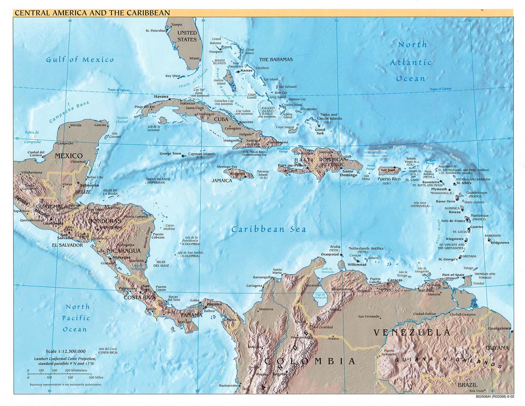
--->The answer is 23. The countries are: Canada, USA, Mexico, Guatemala, Belize, Honduras, El Salvador, Nicaragua, Costa Rica, Panama, Jamaica, Cuba, Haiti, Dominican Republic, Bahamas (these are the ones me and my children know - we haven't yet memorized all the other tiny little countries in the Caribbean which are...), Antigua and Barbuda, St. Kitts and Nevis, Dominica, St. Lucia, Barbados, St. Vincent and the Grenadines, Grenada, Trinidad and Tobago.
Greenland is not technically a country but a province of Denmark, however they've slowly gained more autonomy over the years as they work towards full sovereignty. We've learned where Puerto Rico, US Virgin Islands, British Virgin Islands, and the Cayman Islands are, but these are territories not countries. There are lots of other little Caribbean islands we haven't learned yet which are territories, not countries, but I'm too lazy to list them all!
I also just realized that as I've been quizzing my kids about this we've been including Iceland because it's on our North America maps, but technically Iceland is part of Europe. Oops.
Another weird thing, which I just found out, is that Trinidad and Tobago are considered part of the Caribbean and therefore North America, but those islands used to be attached to South America. Tobago is actually part of a mountain chain that sunk into the sea! Is it just me, or is that cool? <---
I'm curious, did anyone know that off the top of their heads? I know I didn't. :) It's hard to find a good map of North America that doesn't cut off half the Caribbean, so here's a map of most of North America, and a good map of the Caribbean.
The continuing adventures of three amazing boys.

Little Link List
- Sparkpeople.com is the FREE website that helped me lose 30+ pounds in 7 months. A lifestyle, not a diet. This site rocks.
- Snopes - check out all those urban legend emails before passing them on. Um... please! ;)
- Central Asia Institute - Greg Mortenson's organization dedicated to building schools in rural Pakistan and Afghanistan, especially for girls. Also has links to the website for Three Cups of Tea, the amazing book that tells how this all got started.
Sticky Posts
- An amazing reunion that was 60 years in the making.
- Another AMAZING Reunion!
- My thoughts on the difficult job of motherhood
- A breakthrough in how I see myself as a mom.
- This Blog is Brought to You By...
- Girly screams of terror...
- How the foot thing got started... ah memories. Click on the "Feet Feet it's All About Feet" label for the whole story.
- My blurb on one of my all-time favorite books. I've yet to meet someone who didn't LOVE this book. (No, this isn't a book about a boy wizard or sparkly vampires.)
- The blog tag that got a little deep.
- What I think should be the sticky posts of the blogs I visit
Fellow bloggers...
Labels
- APOD (13)
- Art (16)
- Art Masterpiece (3)
- Ben (15)
- Book Blurbs (13)
- Brian (13)
- Chris (19)
- Church Stuff (9)
- Extended Family (28)
- Family (3)
- Feet Feet It's All About Feet (19)
- Flashbacks (2)
- Gratitude Challenge (46)
- John (19)
- Kevin (2)
- Me Me It's All About Me (22)
- Mom (6)
- Mommy stuff (3)
- Movies (2)
- My Testimony (2)
- My Website (2)
- Random Stuff (46)
- Read-Aloud Books (5)
- Recipes (11)
- Scouts (20)
- Service (5)
- Slice of life (34)
- Sparkgirls (6)
- Tammy (2)
- The Boys (40)
- The Foot Picture that Might Have Been (1)
- Vacations and Holidays (35)
- We are amused... (32)
- We are NOT amused (12)
- YouTube Fun (17)
6 comments:
Apparently...I'm NOT smarter than any gradeschooler! Your guy's would stomp my butt at geography.
Man, I just found out I'm really stoopid.
I felt the same way! My little gringo self tends to think there are 3 countries in North America. Even when I remember Central America, I totally forget about the Caribbean.
I'm determined to really commit this stuff to memory. I remember when I was in school learning all the countries and capitals of South America, but I've forgotten almost all of it.
Maybe if I keep quizzing my kids about this stuff over the years, it'll stick for good. Then I can pretend I'm smarter than I am! ;)
That was fun. And no I had no idea about any of that. Ian probably would have known though. He does like geography and is pretty knowledgable in that area. Good thing I married someone smart. Now hopefully my kids will have a chance.
Okay, I knew it was NOT 3 and you were trying to trick us. . . but I can't even begin to name all the island countries. Kudos to you.
If I had 2 seconds to answer, I would've picked 3. And that's why I'm an Accountant (not b/c I can't count, but b/c I am awful at Geography). :)
Post a Comment